Dogsled Trip in the Pagami Creek Fire Area
During the fourth year post-fire, I made a late-winter dogsled trip into the fire area. I was honored to receive funding for this trip and two others the previous year through the Minnesota State Arts Board’s Artist Initiative Program. I am grateful to the people of Minnesota who voted for the Clean Water, Land and Legacy Amendment in 2008 supporting the environment and the arts that funds this program.
Field Notebook – March 9, 2015
My biggest challenge proved to be lining up an adventure travel outfitter willing to take on this unique trip. Dogsled businesses usually offer packaged circuit trips in the Boundary Waters or Superior National Forest. The first outfitter backed out at the last minute two-weeks before the scheduled date.
Through an inspired referral from my friend Lawson Gerdes, I connected with Dave Freeman who in the winter, works for Paul Schurke at Wintergreen Dogsled Adventures in Ely. Dave, with his wife Amy, were 2014 National Geographic Young Explorers of the Year. He responded immediately to my urgent cold-call email and with Paul’s approval, scheduling and planning began in earnest – the trip was on!
Tomahawk Road (Forest Road 377) southeast of Ely is only plowed in the winter if there’s logging activity in the area – and it needed to be plowed and open at least halfway to my sites at the Island River bridge. Dogs really can’t break trail, so we hoped to find the remaining distance to the bridge packed-down by snowmobiles. Importantly, the weather had to cooperate – it couldn’t be too cold and the sky had to be clear enough (not overcast) with picturesque passing clouds, giving me options for light intensity and patterns on the landscape.
On Sunday, March 8th, I drove up to Ely and stayed at the Gerdes’s cabin for the duration of my visit. I am incredibly fortunate to have the encouragement of people who know, live in, and care for this landscape. We share a love of this place and want to see it preserved and flourishing.
The day of the big adventure dawned overcast; but partially-sunny weather in the 40s was predicted. We got an early start because it was important to run the dogs during the coolest part of the day.
We met Dave Freeman at Highway 1 and Tomahawk Road (Forest Road 377) at about 8:30 am, arriving exactly at the same time. The six dogs were in kennel crates on the back of a extended-cab pickup. Also on-board were two sleds – a single and a double. Lawson and I piled our gear into the truck and climbed aboard. We proceeded down a fortunately well-plowed and well-traveled Tomahawk Road, chatting along the way and hoping that as the plowed roadway narrowed, we would be able to get as close as possible. We got within about five miles of the bridge and did not encounter any logging trucks along the way, and good fortune - the unplowed roadway beyond was packed down by snowmobile tracks.
Dave parked the truck in a widened turn-around at the end of the plowed portion of the road. He unloaded the truck, then the dogs – Jack and Pecan, the joint-lead Inuit dogs for my sled along with Bullseye, a skinny, wily black fellow. Lawson’s sled had Flash, another twin to Bullseye, and Galena as leads for her sled. The third dog, a white mutt, was initially reluctant and wanted to climb aboard Lawson’s sled rather than pull it.
My Inuit pair were muscular, bulky, steady dogs – once they were pulling – but after unloading and during harnessing a noisy vocalizing ensued and rather undignified jostling and rolling in the snow. It was a challenge to get them harnessed.
Dave started out, skate-skiing in the lead 50-feet ahead of us, followed by me in the lead sled and Lawson in the rear. Her team was much friskier and faster than mine – but with me in the middle with the steady Inuits – the pace was kept slower so the dogs wouldn’t overheat. We arrived at the Island River bridge (about five miles distant) in almost no time at all. But not before a rocky start – Lawson got tossed off her sled while going over a bumpy mogul formed by the snowplow. However, once started, the dogs set a steady pace and it grew quiet as we glided along.
I learned three commands to shout – “hike” to go, “whoa” to stop, and “loose sled” when I fell off. Both Lawson and I experienced our sleds tipping when the dogs doubled back unexpectedly. Dave said the dogs were being naughty. I got the impression that the dogs knew we were rookie sled-handlers and were playing with us. When I yelled, “hike,” released the brake and the dogs surged ahead, I believe it was because they wanted to follow Dave who was in the lead, not because I ordered them to “hike.”
We arrived at the Island River bridge at about 10:30 am. Dave tied-down the dogs and the sleds, and the animals proceeded to auger into the deep snow pack, curl up and go to sleep during what was now a quite sunny and warm day.
We strapped on our snowshoes and with Lawson in the lead to break trail, set out across the frozen meadow skirting Island River. The snow was wet and heavy, melting in the sun. We slogged through the meadow and then picked our way through downed trees to head up-slope. Before we began, we had strategized about how to get to the sites without leaving tracks across a field of snow that might later mar a photographic view.
The going became more difficult as we headed up-slope into deeper drifted areas. In some places the snow was several feet deep and because it was melting, when we lifted our snowshoes, heavy wet snow weighing several pounds came along.
The snowy landscape looked so foreign! I had great difficulty finding my first photo point: Site #2. But once I saw the geologic marker on the hillside – at least I knew the gradient, and was able to navigate to Site #2 which is marked by a faded pink ribbon I tied to an upright tree during my first visit in 2012.
With most of the interesting roots at ground level and therefore under snow, it was challenging to devise compositions. At Site #2, I used the wide-angle lens to encompass more of the hillside context and to work with the shadows of the upright trees behind me that were falling onto the scene. The light was a little hazy, but delicate; I was glad the sun was not blasting away.
Site #2, March 2015
Then came a cloudy period lasting almost two hours. The sun would peep through openings in the cloud deck for brief periods, throwing luminous beams across isolated areas of the landscape for a few seconds, often following the course of the frozen, snow-covered river. I did several short videos of this phenomena.
As the day wore on, blue sky with scattered clouds and then full sun came on. We trudged across the meadow at the front of an inlet and then up to the high point with the rock outcrop, Site #4. I produced several black-and-white exposures here. The sun came out just in time to dapple the background, painting the far hillsides in light and increasing the contrast between the blackened trees, roots, and rock outcrops, and the field of white.
Site #4, March 2015
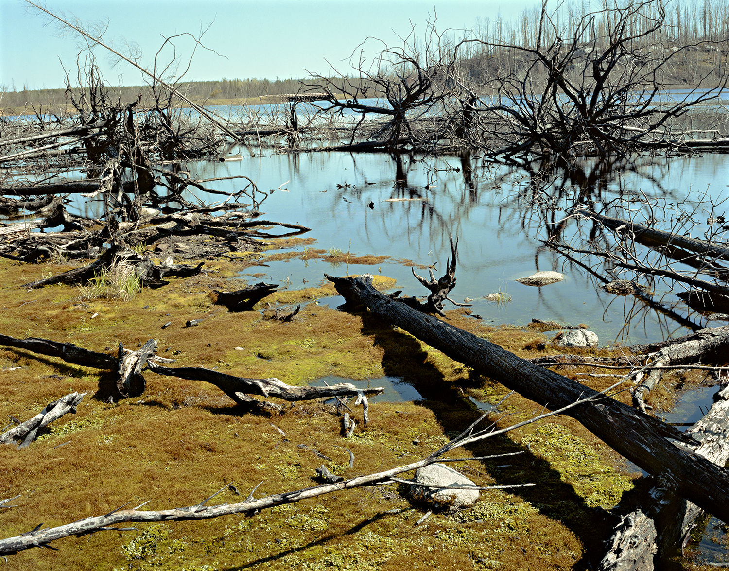
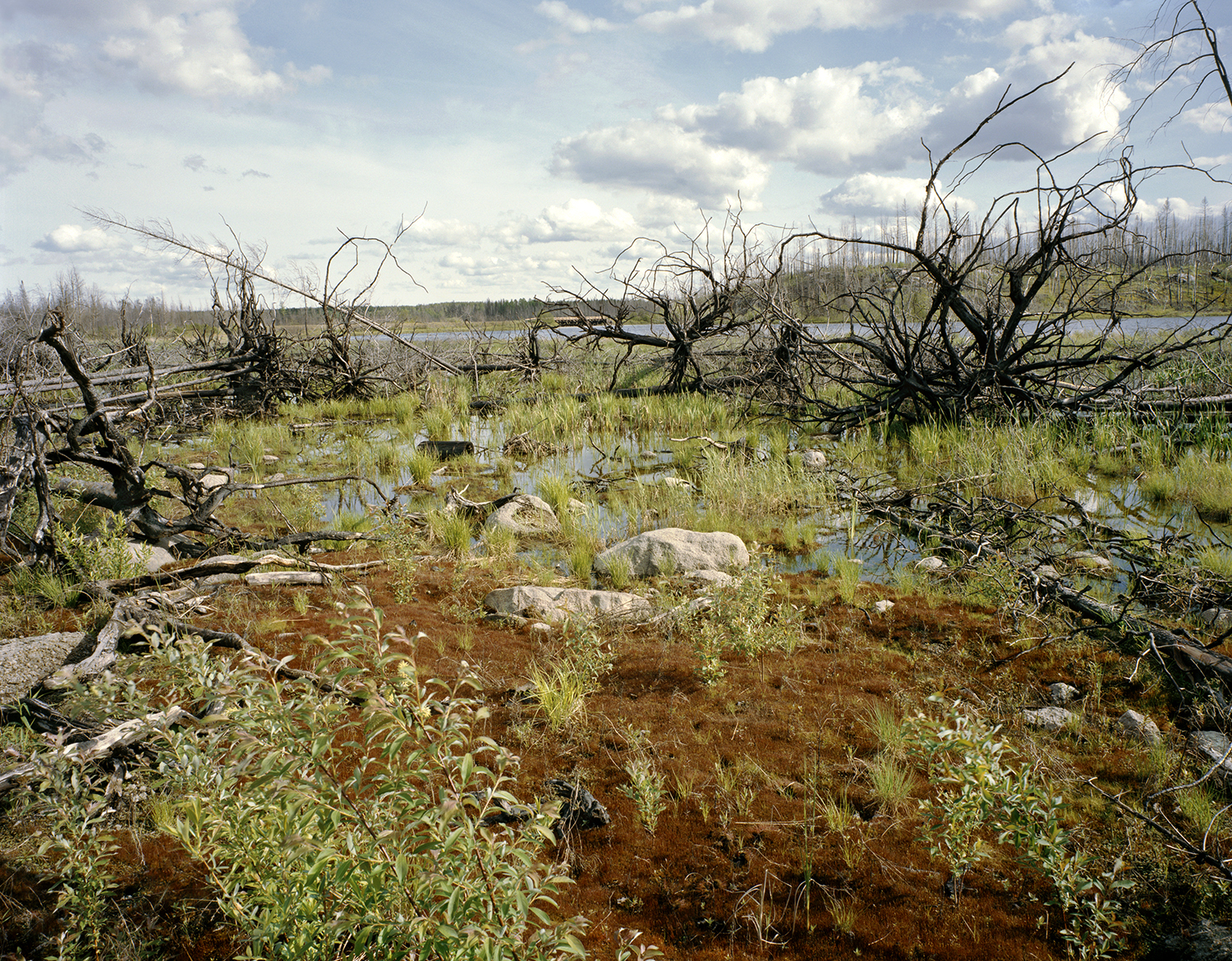
At Site #3, the overlook to Island River which is the broadest view of the burned river edge, I switched to color because of the delicacy of the blue sky, puffy clouds, the band of light illuminating the frozen river, and the back-lit blackened trees.
Site #3, March 2015
Site #3 same view as above in June 2014
The last location was the water’s edge and because the ground plane plants (mostly emerging willows, bulrush, cattails, sedges) were covered with snow, this image became about the moose footprints that led into the frame and around one of the upended tree roots. I used the wide-angle here, as well, and worked closer to the trees.
At this point, I was running out of energy – I had been so busy that I’d just grabbed a few bites of cheese, crackers and trail mix – and I decided that this was it; I wouldn’t make it to Site #1.
Site #6, March 2015
I headed back to Lawson and Dave waiting for me at the bridge. The sunlight was fading and it was becoming hazy. I had also stayed out much longer than the 2 ½ hours I had told Dave that it would take to make the pictures.
We re-packed the gear and woke up the dogs. They were grouchy and groggy. Both Lawson and I had several false-starts because the dogs turned around and tipped the sleds. My dogs saw the opportunity to pitch me off the sled and took it. I screamed “loose sled” and Dave, skate-skiing about thirty feet ahead, spun around, madly yelled and waved his arms as the dogs barreled toward him. He grabbed the lead dog’s harness just in time to stop them from making a break for it – I would’ve had a five-mile walk back to the truck otherwise.
Dogs anxious to go (especially Bullseye) while I stand firm on the brake!
I’m really thankful that we were in Dave’s capable hands. Dave had hung out with me while I was photographing and it’s clear he believes in and supports what I’m doing. I owe him my thanks.
The dogsled trip was long anticipated, planned for, and imagined. I asked much of myself (both physically and artistically) and of Lawson and Dave – and there was not one moment of impatience – nothing interrupted the magical flow. Equanimity: mental calmness, composure and evenness of temper, especially in a difficult situation. Only the dogs were temperamental!
What did I observe? The whiteness of snow defining the topographic ghost of the landscape and pure silence with the echoes of muffled forest sounds (when the dogs weren’t vocalizing). This visit was more about impressions – and the resulting photographs less literal – than other visits. Winter gives the landscape an other-worldly aspect.